
Photogrammetry & 3D Modeling with Drones
Improve planning, enhance decision-making, and gain accurate visual data with advanced UAV photogrammetry and 3D modeling solutions for industrial and commercial applications.
The Challenge of Obtaining Accurate Site Data
Traditional surveying and documentation methods can be time-consuming, costly, and difficult to perform in large-scale or hard-to-access environments. Incomplete data collection may lead to planning errors, project delays, and increased operational costs.
Industrial facilities, construction sites, and infrastructure projects require reliable spatial information to support inspections, measurements, and progress tracking.
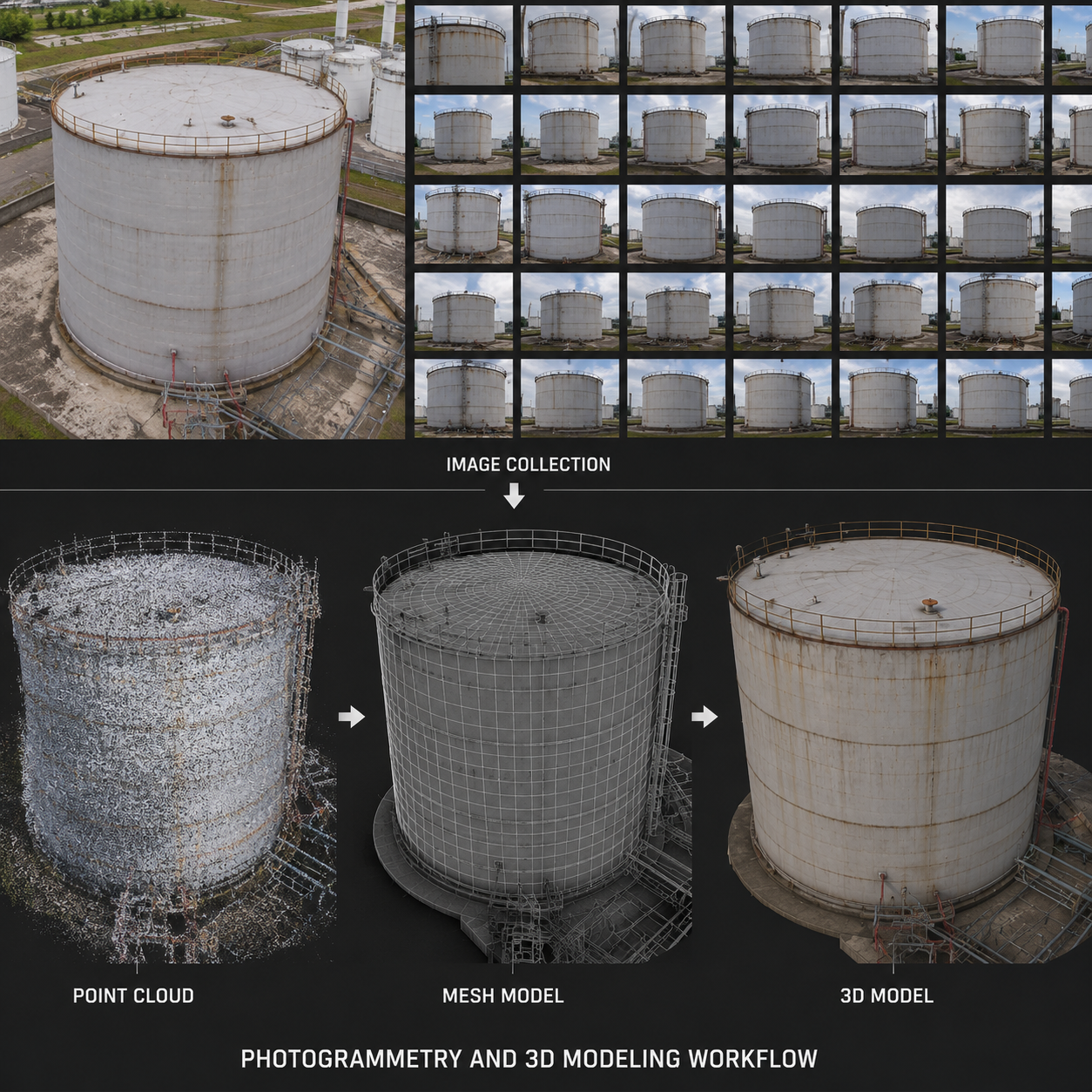
A Faster and More Accurate Data Collection Solution
Our drone-based photogrammetry services provide highly detailed aerial data that can be transformed into orthomosaics, point clouds, digital surface models, and accurate 3D representations.
Using advanced UAV technology, we deliver precise measurements and visual documentation while reducing field time, minimizing risks, and improving project efficiency.
Key Benefits of Drone Photogrammetry & 3D Modeling

High-accuracy spatial data collection

Faster project execution

Reduced surveying costs

Improved planning and decision-making

Safe access to difficult environments

Detailed 3D visualizations

Enhanced project monitoring

Reliable documentation for technical analysis
What's Included in Our Service
- Initial project assessment and consultation
- Flight planning and mission design
- High-resolution aerial data acquisition
- Generation of orthomosaic maps
- Creation of point clouds and 3D models
- Data processing and quality verification
- Delivery of technical reports and digital outputs
Where This Service Applies
- Construction and infrastructure projects
- Industrial facilities and plants
- Mining and quarry operations
- Energy and utility projects
- Land development and site planning
- Asset management and facility documentation
Why Choose UAV Consulting & Services
Advanced UAV mapping technology
Accurate and reliable data processing
Efficient and cost-effective solutions
Experienced technical professionals
Strong commitment to precision and safety
High-quality deliverables for industrial applications
Frequently Asked Questions
Industrial Drone Services provide a safer and more efficient alternative to traditional inspection methods.
How accurate are drone-generated 3D models?
Drone photogrammetry can achieve highly accurate results when proper flight planning and processing methods are applied. Accuracy levels depend on project requirements, site conditions, and the use of control points when necessary.
What deliverables can I expect from this service?
Deliverables may include orthomosaic maps, point clouds, digital elevation models, textured 3D models, measurements, and technical reports tailored to the specific needs of your project.
Can drone photogrammetry be used for ongoing project monitoring?
Yes. Periodic drone surveys provide valuable insights into project progress, allowing stakeholders to compare data over time and make informed decisions throughout the project lifecycle.
What industries benefit most from drone mapping and modeling?
Drone photogrammetry is widely used in construction, mining, energy, industrial facilities, land development, infrastructure inspections, and asset management projects requiring accurate spatial information.

Transform Data into Actionable Insights Today
Contact UAV Consulting & Services to schedule your drone photogrammetry and 3D modeling service and gain the accurate data needed to optimize planning, improve efficiency, and support informed decision-making.